Satellite Image Detection
Challenge
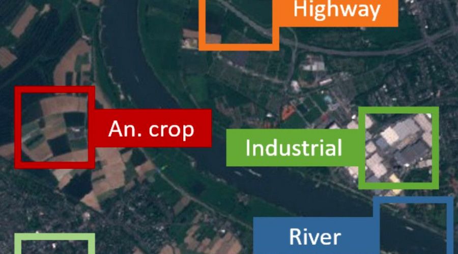
Satellites produce 1000's of images daily. With increasing resolution and shorter frequency, satellite imagery can analyze several near-real-time changes. Simply classifying each square of land as vegetation, road use, farmland, or water is enormously helpful for climate scientists, planners, and the intelligence community. Interplay® manages the overwhelming volume of images produced.
Solution
Classifying land usage from satellite imagery revolutionizes how we approach national security, economic analysis, and environmental impact. With an almost constant stream of satellite imagery becoming available from both commercial and government sources, analyzing that imagery at scale can realistically only be done by computers. Building upon existing work we’ve done for image analyses in retail, the oil & gas industry, and healthcare, we now partner with Masego Inc. to deploy Interplay® and its flexible, dynamic, and engine-agnostic AI capabilities for satellite image analyses.
Next Steps
For this project, we used Interplay to rapidly prototype a data flow that could accept a standardized training data set and optimally train the engines. Then, Interplay outputs a simple reporting mechanism that shows the image being analyzed, its categorization, and its degree of accuracy (almost always above 99%).
Project Profile
Client:
Military
Goal:
Quantify objects automatically
Development Time:
5 weeks
Deployment:
Undisclosed